
I got up early Tuesday morning, packed and was ready for breakfast by 6:30. I was pretty excited to be going home. I missed Nancy and the boys (cats). 17 days away from home is a long time for me, for others 17 days is nothing.
I was on the road by 6:50, that's 7:50 central time. I gassed 3 times, and grabbed a quick lunch at the Taco John's in Luvern, MN. I finished the 541 mile day by 4:30.
I brought home a few things that I found for Nancy, a sample of beach sand from the Pacific, a huge pine cone, and a couple of crab shells. She was pleased!
Total miles on this trip 5780.9 through 9 states, with only day or two of light rain.
The only mechanical issue I had was the loss of one of the quick connect retainers on my luggage. I didn't notice that until I got home. A replacement and a spare have been ordered.
I also learned that my underwear of choice for a long trip is not the cotton briefs I usually wear everyday, but the stretchy, black, polyester boxers that look like bicycling shorts. Add a bit of Palmer's Bottom Butter, and an Aleve and I'm good to go!!
My bike needs a lot of service in the next few weeks. I need to do an oil change, clean the chain, change brake fluid, check the air filter, and give it a very good cleaning. It's looking pretty ratty!
Wednesday, June 29, 2011
Monday, June 27, 2011
Days 15 and 16.
I'm fine, I was just too tired last night to post anything. After I took a shower, I fell asleep without blogging.
Day 15.
Grangeville, Idaho to White Sulphur Springs, Montana.
I started the day knowing that I'd get to ride Hwy 12 over Lolo Pass. I was excited to ride that road again. I did it last year with John. You can read more about that day HERE. I was having a good time. I had shot a few pictures along Hwy 13 and even got a nice clear one of the "winding road next 99 miles" sign. I stopped to get another picture of the fast moving river, when I noticed the camera was telling me there was no memory card in it. CRAP! All the good pictures I thought I had! Oh well.
From Lolo, I went through Missoula, Helena, and stopped in White Sulphur Springs. I think I was asleep before 9:00 p.m.
I think the rivers along Hwys 13 and 12 are higher this year, than they were last year. There are a lot more areas of white water than I remember from last year. There were also a lot of small islands that had water running over them. There were 2 or 3 foot tall pine trees on those islands.


Another state sign.

There's still snow at Lolo Pass

I saw another one of these things just outside of White Sulphur Springs... any guesses???

Day 16.
White Sulphur Springs, Montana to Wall, South Dakota.
I slept so good last night, that I was up a packed and ready to go by 6:30. I had breakfast at a little place in town called Dori's Cafe. I had scrambled eggs with diced ham in them, toast and hash browns. It was very good. I was east bound by 7:00.
Just 20 miles out of town, I looked down at the gas gauge and looked up to see a deer standing on the left shoulder. He was facing left, looking off the road. I thought he'd just keep going and would be off the roadway, but no, he decided to turn around, and run back across my lane. I missed him by a foot, at the most. I took a short break on the side of the road, then made my way to Harlowtown for gas.
There were a TON of small gnat type bugs on the road. I had to pull in at almost every town and clean my face shield. I was trying to make good time, so most at most of the stops I didn't even get off the bike to clean the face shield.


Before I knew it, I was in Belle Fourche. I gassed up and was thinking about where to end the day. I felt good and it was still only 2:30. I had been thinking of the beef tips from American West restaurant for the last 100 miles. If it were closer to supper time I would've stopped. I drove through Sturgis and stopped in Rapid City. I knew there were a bunch of restaurants near exit 59. I chose the Golden Corral. I ended the day at the Super 8 in Wall.
I should be home before too late tomorrow.
Saturday, June 25, 2011
Day 14. Idaho
I didn't take many pictures today. I pretty much just rode from Burns, OR to Grangeville, ID. I didn't sleep very well last night. I now realize that I can't drink caffeine anymore. I had a hard time falling asleep, and my ass has been dragging all day.
I did think that this was an interesting sign...

I got one more state sign.

The Little Salmon River..

I did think that this was an interesting sign...

I got one more state sign.

The Little Salmon River..

Friday, June 24, 2011
Day 13. Crossing Oregon.
I turned and headed east this morning. I'm, at least, travelling the direction of home. I'm not sure when, or even how, I'll get there. It will be good to get home.
I rode two very beautiful Oregon roads today, OR-38 and OR-126. From Reedsport, I took OR-38, AKA, the Umpqua Highway. It follows along side the Umpqua River. On parts of the highway the trees are so close to the road, that you're driving under a lush green canopy. There are many sections where they had to cut into the rock to make room for the road and the walls are just feet from the roadway. There were several small waterfalls along the road and a tunnel through the hill.


Highway 38 runs through Drain, and out to I-5. I took I-5 up to Eugene/Springfield and caught 126 east. A mile or so later you begin to think you're in the middle of nowhere. East of Vida there is a really cool covered bridge over the McKenzie River. Here's some more info.

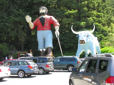
I also spotted this. I have no idea what it is, but I've seen 2 or 3 identical structures on this trip. It's very large and several stories tall. Any ideas???

I wanted to take 242 out to Sisters, but the road is still closed. Too much snow.

I had to take 126 to 20 to get to Sisters. The town is named after the nearby 3 mountain tops, each just a bit over 10,000 feet. I didn't stop in Sisters, but I got the feeling it is kind of a tourist town.


I was thinking of riding all the way to Ontario, OR, but instead stopped in Burns. I didn't feel like riding another 2 and a half hours.
I rode two very beautiful Oregon roads today, OR-38 and OR-126. From Reedsport, I took OR-38, AKA, the Umpqua Highway. It follows along side the Umpqua River. On parts of the highway the trees are so close to the road, that you're driving under a lush green canopy. There are many sections where they had to cut into the rock to make room for the road and the walls are just feet from the roadway. There were several small waterfalls along the road and a tunnel through the hill.


Highway 38 runs through Drain, and out to I-5. I took I-5 up to Eugene/Springfield and caught 126 east. A mile or so later you begin to think you're in the middle of nowhere. East of Vida there is a really cool covered bridge over the McKenzie River. Here's some more info.

I also spotted this. I have no idea what it is, but I've seen 2 or 3 identical structures on this trip. It's very large and several stories tall. Any ideas???

I wanted to take 242 out to Sisters, but the road is still closed. Too much snow.

I had to take 126 to 20 to get to Sisters. The town is named after the nearby 3 mountain tops, each just a bit over 10,000 feet. I didn't stop in Sisters, but I got the feeling it is kind of a tourist town.


I was thinking of riding all the way to Ontario, OR, but instead stopped in Burns. I didn't feel like riding another 2 and a half hours.
Day 12. Fortuna CA to Reedsport, OR
Last night, I pampered myself and stayed at the Super 8 in Fortuna. I know that really doesn't sound too fancy, but I'm trying to keep costs down. I also had to get the "Bates Motel" of Quincy feeling off of me. It was good to have the continental breakfast of fresh fruit, a waffle and juice.
I spent the day driving up the coast on US-101.
The first stop was a California rest stop in the Redwoods.


A field of elk.

I finally get to the Pacific Ocean.


I thought this was neat. On each end of the bridge over the Klamath River, there are 2 bears.


I saw this and thought I was in Brainerd, MN.
A few more from further north.


I've seen commercials for Jack in the Box and thought I'd try it. I stopped in Crescent City, CA for lunch. It wasn't bad.

Into Oregon.

In Gold Beach, OR, right along side the road, is the office for Backwoods Home magazine I've never had a subscription, but I've read many issues over the years. I stopped in and picked up the current issue. I may have to subscribe.

I ended the night in Reedsport, OR. I'm back to low dollar hotels. Tonights hotel was $43.00 with no extras.
Tommorow, I turn east for home.
I spent the day driving up the coast on US-101.
The first stop was a California rest stop in the Redwoods.


A field of elk.

I finally get to the Pacific Ocean.


I thought this was neat. On each end of the bridge over the Klamath River, there are 2 bears.


I saw this and thought I was in Brainerd, MN.

A few more from further north.


I've seen commercials for Jack in the Box and thought I'd try it. I stopped in Crescent City, CA for lunch. It wasn't bad.

Into Oregon.

In Gold Beach, OR, right along side the road, is the office for Backwoods Home magazine I've never had a subscription, but I've read many issues over the years. I stopped in and picked up the current issue. I may have to subscribe.

I ended the night in Reedsport, OR. I'm back to low dollar hotels. Tonights hotel was $43.00 with no extras.
Tommorow, I turn east for home.
Thursday, June 23, 2011
Day 11. 140 Mile Workout and Avenue of the Giants.
I got up this morning and checked out of my motel... it was one step up from the "Bates Motel". I was ready to cross 2 more items off my list of places I wanted to see while on this road trip. I headed north on CA-89, all the way to CA-36, and took it west. A lot of the roads I've been on follow along the sides of rivers, and others were cut into the sides of the mountains. CA-36 has both. I stopped at a grocery store in Mineral. I was surprised, for being in the middle of nowhere they had everything. A huge Mexican and Asian section, better than some of the larger grocery stores back home! I picked up some more supplies, including dried tart cherries and craisins.
CA-36 crosses over the Sierra Nevada Mountain Range, then drops down into the Sacramento Valley, and finally over the Coastal Range, and it ends at highway 101, near the ocean. The temps today were nice and cool at the higher elevations, but it was 96 degrees at 1100 when I crossed the valley.
A short ways out of Red Bluff, in the valley, is this sign. I have seen it for years on web sites like sport-touring.net and pashnit.com. It's kind of a motorcyclists icon in northern California.

It was a long time from when I passed the sign, before the temps began to drop again and for me to gain elevation. It is a very fun ride. Traffic was light, and there were plenty of places to let other cars go by. I was in no hurry to reach the end. It was a heck of a workout, maneuvering a 650 lb, large, sport bike that's fully loaded for travelling, around all those curves!!! I'm beat!
When I came to the end of CA-36, I went south on Hwy 101.

I wanted to see some Giant Redwoods, so I went here.

The road is actually the old Highway 101. A newer, multi laned, road now runs almost right along side the old road. The giant trees are right next to the roadway. I still can't believe just how big they are. I saw pictures of them when I was in school, but they are so much bigger in real life. WOW, what a sight.


A couple more pictures from today.


Wednesday, June 22, 2011
Day 10. On to Quincy.
Today was not a very productive day. It started warm and just got hotter. In the 5 minutes it took to drive from the hotel to Rodz Grill for breakfast, the temp was warm enough to make my hands sweat and my gloves moist.
Rodz Grill, Angels Camp, CA. A neat, car themed diner.


My plan for today was to follow CA-49 up from Angels Camp, through Placerville, through Auburn, up to CA-89, to somewhere on CA-36. Things didn't go quite that way...
I was following the GPS and doing ok. Somewhere in Auburn things went wrong. The GPS will occasionally call the road I'm on by the local name, such as "Main Street", instead of the route number, like "49". So I wasn't to concerned when it told me I was on Auburn-Folsom Road. I should've been a bit more aware of where I was going, but it was HOT and I think the temperature got to my brain! I didn't realize I was so lost until I saw a sign for Rancho Cordova. I found my way onto Hwy 50 and got off back in Placerville. By the time I got back up to Auburn, I had wasted 3 hours! It was fun to re-ride that section of 49 again, but it was a time killer.
I found my way through Auburn, again, and managed to stay on 49 and not get lost. CA-49, especially where it runs along side the Yuba River, is a great road for a motorcycle!


CA-49 takes you through neat little towns like Downieville and Sierra City.

I had set my GPS to guide me to Quincy. It told me to turn north onto Gold Lake Road. As the elevation climbed, the temps dropped. It wasn't long before I was into the snow again. I wanted to stop and lay in the snow for a while and cool off. While I was following Gold Lake Road, the GPS told me to turn right onto a forest service road. I made the turn and in less than 50 feet I had to stop. Darn GPS.

As if wasting 3 hours because I got lost, and being sent down a snow covered road weren't enough, I got stung. After getting onto CA-89 from Gold Lake Road, it was very hot. I was running with my jacket totally unzipped. I was riding along and felt a bug hit me in my throat. It hit hard. Then I felt a pain in my left shoulder, right under the collar bone. I felt something in my shirt moving towards my belly. I grabbed at it with one hand, while trying to get to the side of the road and stop the bike. Once I got stopped, I ripped the my shirt out from my pants and a big fuzzy bumble bee fell on the ground.
I'd had enough. I stopped in Quincy for the night, had a Subway, and grabbed a hotel room. While I've been typing this, I've lost the internet connection 3 times. Good night!
Subscribe to:
Posts (Atom)
